Recreate the Midnight Ride
Recreate the Ride of Paul Revere
Paul Revere used a horse on his famous ride from Charlestown to Lexington – but you will want to use a car. Revere encountered rough roads and enemy troops and had only the light of the moon to guide his way. You will encounter modern hazards – traffic, one way streets, traffic circles and construction. Paul Revere made it. So can you.
To Visit the Paul Revere House First
Although Revere started his ride in Charlestown, you may want to start your trip with a visit to the Paul Revere House. The best parking is along Atlantic and Commercial Street near Fleet Street. Once you park, you can walk up Fleet Street. Go three streets and turn left on Garden Court. Walk down into the square and you will find the Revere House on the right hand side, the only wooden house on the street.
Once you have visited the Paul Revere House, return to your car and follow the directions below.
To Follow the Route of the Ride
Stay to the left side of North Square in front of the Revere House.
Make first Left onto Prince St.
In one (short) block turn Right onto Hanover St.
At the end of Hanover St. turn Left onto Commercial St., move to the far right lane.
Take the first Right onto North Washington St. (Charlestown) Bridge.
At end of the bridge turn Right onto Chelsea St.
Take the first Left onto Warren St.
Warren St. leads into Main St. in about 7 blocks. Main St. intersects with Bunker Hill St. at the Schraffts Building (tall clock tower.) Turn Left over the railroad tracks (this is still Main St./Bunker Hill St.) Boston Fire Dept is straight ahead.
Take a Right onto the Sullivan Square rotary. There are only right hand turns and trees will be on your left. Take your 2nd Right out of the rotary.
This is still Main St. for a few blocks then becomes Mystic Ave. When you see the “Entering Somerville” sign take the first Left at the lights and go under the I-93 overpass, there is “To Rt 28-38 Medford” sign pointing left (Alfred Lombardi St.)
Turn Right onto Broadway (the signs point to Rt. 28)
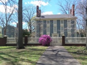
Courtesy of Royall House & Slave Quarters, Medford MA
Continue on Broadway for 1.2 miles to the top of Winter Hill.
Take a Right at the fork onto Main St.
Continue on Main St. into Medford. (The Royall House and Slave Quarters is on the left. Revere wouldn’t stop at a Loyalist’s home, but you can!)
Merge onto Main St. and bear Right.
At the top sign with a flashing red light take a Left onto Mystic Ave./Main St. Medford You will see a Medford Police Station on the right.
Continue on Main St. into Medford Square. You will be making a loop around here.
Take your 2nd Right on Riverside and get in the left hand lane.
Take a Left at City Hall Mall. Move into the Middle Lane and make a Left on Salem St.
Now you should be in the Right hand lane for Rt. 60 W. This turns into High St. and continues through Medford Square.
You should see a Brown “Revere’s Ride” sign about a .1 mile outside of Medford Square, confirming you are going the right way.
At the next rotary take the 2nd Right to stay on Rt. 60 W/High St.
You should see another Brown “Revere’s Ride” sign .8 miles from the rotary.
Go over the railroad tracks and bear Left to stay on Rt. 60 W.
Follow High St./Rt. 60 W to the town of Arlington. High St. crosses the Mystic River and becomes Medford St.
Follow signs that direct you towards Lexington and Rte. 2 A.
Bear Right on Chestnut St. This street will end in a “T”. Take a Left on Mystic St.
Get in the Right lane and at the first light turn Right onto Mass. Ave
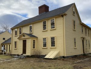
Jason Russell House
[When you turn on Mass. Ave the Dallin Museum will be on your right almost immediately.][In .2 of a mile you will see Jason St. on your left (a few blocks past Arlington town hall) home of the Jason Russell House & Arlington Historical Society. ]
Continue 1 mile on Mass Ave. to the end of the 1100 block.
At the flashing yellow light take the Left fork onto Appleton St. (Church on your left and a yellow house on your right)
After a few blocks take the Right fork onto Paul Revere Road.
There is a jog across Park Ave. (turn Right and immediately Left) to continue on Paul Revere Road. Continue to the stop sign at the end of the road.
Take a Left to re-join Mass Ave.
Continue on Mass. Ave. all the way to Lexington. You will pass Munroe Tavern on your left. One mile from the Tavern you will see Lexington Green on your Left.
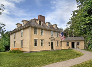
Buckman Tavern; Courtesy of Lexington Historical Society, Lexington MA
At the Captain Parker Statue, take the Right fork onto Bedford St and another Right fork onto Hancock St. You will see Buckman Tavern on your right.
In about .25 mile you will come to Revere’s assigned destination: The Hancock-Clarke House where Revere alarmed Samuel Adams and John Hancock. There is parking in front of the house.
For extra credit, retrace your way to Lexington Green and continue driving to find the site of Revere’s capture.
Go Right on Mass. Ave. In 1.1 miles, immediately after you cross over I-95 turn Right on Wood St.
Take your first Left onto Old Mass. Ave. (you will see a ‘Welcome to Minute Man National Historic Park’ sign.)
About .5 mile from the sign take a Right on Marrett Rd/Rt. 2A.
At the “T” turn Right, (there’s no street sign.)
1.1 miles later you will see the Paul Revere Capture site on your Right, look for the brown sign. There is a parking area before the marker.
Your ride is complete!